Monday, July 11, 2011
OPSIG industry DB
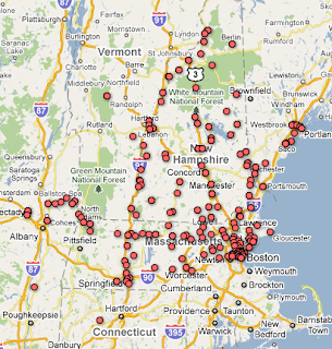
The OPSIG is a special interest group focusing on railroad operations, especially as they apply to model railroads. They maintain a database of real world and fictional industries, including localities, serving railroads, and what was shipped and received. It has tens of thousands of entries, split across four text files. Doing it in this way is a great idea, as these are easy to reuse (as opposed to locking them in some proprietary format). I ran a few scripts to clean them up (convert things like B&M, BM to be BM, have four digit years), pruned out non-real-world industries, and put it in Google Fusion Tables. This allows automatic geocoding (converting "Dover, NH" to a latitude and longitude) to put industries on the map and also allows filtering. Results can be viewed as a table or a map. You can filter for just industries served by the B&M (table or map), for all industries dealing with paper, or even combined things, like all auto-related industries served by UP in California (here).
The main page for the database is here.
Note that there are some weirdnesses. Some of the geocoding is off (a few Arizona localities are placed in Mexico), some of the raw data just seems wrong (like a railroad being given an industry in a weird part of the country for that line). Points in the same locality (New York, NY) overlap each other, so it looks like each place has one or zero industries (though don't forget about filtering). Overall, though, it should be pretty useful. I made it because I wanted to look at some of the industries served by the B&M in various towns, but then I figured, why not just do the general solution, as the data are already there?
The credit for this goes to the members of the OPSIG who created and maintain this amazing database, as well as Google for its free Google Fusion Tables tool. Remember that while the database is a product of the OPSIG, this particular use of it isn't, so the blame for any oddness should go to me, not them. They are still accepting new data. I'm not going to spend a lot of time keeping this up (my hobby is model railroading, not database creation) but there are ways to add collaborators to the document to make changes.
Sunday, July 10, 2011
Free-mo N
I'd been thinking of making my layout as a set of Ntrak modules (even went so far as to buy their booklets) but didn't want the whole three mainlines thing. I then decided to do the garage as one big shelf, but I haven't been working on it. Also, I've been growing concerned that it's not flexible: when we move, if I want to try modeling another area, etc., I'm stuck. I read about European Freemo and was intrigued, and heard about it being done in the US (but with an extra hyphen: Free-mo). It's a nice concept: specify the ends, so modules fit together, specify good track standards, and leave the rest up to the modeler. It's designed more for operation than display -- while Ntrak has 3 main lines with lots of action, Free-mo has a single main line (usually), and the European groups sometimes just rent out a large room for an operating session just for operators. They do have displays, however: I remember seeing a multi-legged centipede of a layout at a model railroad show that in retrospect probably was a Free-mo layout. There are both HO and N scale standards. The standards include scenery standards to keep modules consistent (no Mojave desert module sitting next to autumn in New Hampshire). However, I'd like to do winter scenery, so it won't be Free-mo compatible. This isn't a criticism of the Free-mo standard -- I think their scenery standard makes sense, just not what I want to do for my home layout [they also prohibit Peco code 55 track and turnouts (wrong tie spacing), which I've already invested in]. However, I will adopt basically their standards for everything else (track feeders 24 gauge or bigger, bus wire 12 gauge, butt joints between modules) -- if experts hash out the best way to do something, it's a good idea to go with that absent other information.
Subscribe to:
Comments (Atom)

